By Jason Samenow and Andrew Freedman.
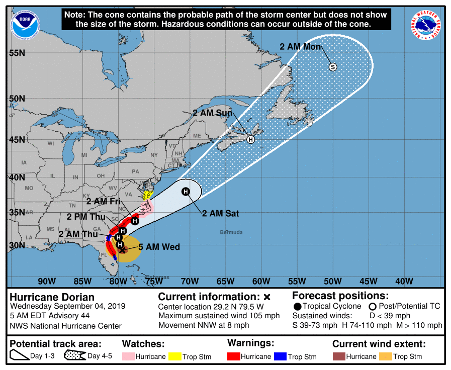
Hurricane Dorian gradually leaves Florida behind Wednesday, setting its sights on the coasts of Georgia and then the Carolinas. These areas face a triple threat of “destructive winds, flooding rains, and life-threatening storm surges,” according to the National Hurricane Center.
While Dorian has stayed far enough off the coast to largely spare Florida from the worst of its wrath, it is forecast to make a much closer approach to the coastline of the Carolinas between late Wednesday and Thursday and could even make landfall. Impacts are thus expected to be more severe.
Around Charleston, S.C., for example, wind gusts could hit 80 mph, and water levels could rank among the top five levels ever recorded due to the combination of ocean surge and up to 15 inches of rain. Higher wind gusts could lash North Carolina’s Outer Banks, leading to power outages and damage.
Even the Virginia Tidewater and southern Delmarva Peninsula could endure tropical storm conditions by Friday, after which the storm is expected to finally race out to sea.
The Category 2 storm, while no longer the powerhouse that devastated the northwestern Bahamas, has expanded in size. That means its strong winds cover a larger area, capable of generating giant waves and pushing large amounts of water toward the shore. There were signs that Dorian is attempting to intensify over the waters northeast of Florida on Wednesday morning, with a ring of thunderstorms building up around its center. If this trend continues, it could mean even worse impacts for the Carolinas.
READ MORE at washingtonpost.com