Boating, Fishing, and Travel Information for San Diego, CA
See our weather radar, buoy data, marine forecast, and current weather for San Diego, California.
Other Helpful Resources:
- Beaches in San Diego
- San Diego City Offices
- Chamber of Commerce
- San Diego Tourism Authority
- Marinas in San Diego
The Coast Guard Station in San Diego is located at: 2710 North Harbor Drive, San Diego, CA, United States 92101. Their telephone number is (619) 278-7000
Seasonal Weather in San Diego:
The mild climate from San Diego to Point Arguello is controlled by the Pacific high-pressure system. Aided by the sea breeze, it brings winds from off the water, mainly south through north, which help keep coastal temperatures up in winter and down in summer. Coldest average temperatures range from the middle to upper fifties (12° to 16°C), while summertime readings are most often in the seventies (22° to 27°C). Occasionally a hot dry flow off the land in autumn will cause temperatures to soar into the nineties (33° to 38°C), and a rare winter outbreak from the east can drop temperatures to below freezing (<0°C). Winter is the rainy season, although not much rain falls along these coasts.
In the San Diego Bay area, visibilities are reduced to less than 0.5 mile (0.9 km), mostly by radiation fog, on about 3 to 7 days per month from September through April. December is the foggiest month. This fog is worst during the late night and early morning hours. Dense fog is as frequent at North Island as it is at Imperial Beach. However, sound signals indicate that in general it is foggier around the entrance to the bay than it is in the north sections. For example, in December, the sound signal at Point Loma is operating about 20 percent of the time, compared to 10 percent at Ballast Point.
Boating in San Diego, CA Map View
Prominent Features:
Point Loma, on the west side of the entrance to San Diego Bay, is a ridged peninsula with heights of about 400 feet. The ridge is bare of trees except in the gullies and where planted around the houses near the summit, and is sparsely covered with grass, sagebrush, and cactus. The tanks and buildings of a sewage treatment plant are conspicuous about 0.9 mile north of the point. At a distance the point usually has the appearance of an island. Point Loma Light (32°39’54″N., 117°14’34″W.), 88 feet above the water, is shown from a black house on a 90-foot white square pyramidal skeleton tower at the south end of the point. A mariner radio activated sound signal at the light is initiated by keying the microphone five times on VHF-FM channel 81A. Thick kelp beds extend more than 1.5 miles south of the point, and a sunken wreck is about 0.5 mile south of the light.
On the nearer approach, an abandoned lighthouse will be seen on the highest part of the hill immediately back of Point Loma Light. The old lighthouse and grounds form the Cabrillo National Monument, honoring the discoverer of San Diego Bay. The statue of Cabrillo, about 300 yards northeast of the abandoned lighthouse, is reported to be an excellent mark when fog obscures the old lighthouse. From inside the bay, prominent objects along the crest of the ridge are a large red and white checkered elevated tank, a green standpipe, and a tall lookout tower all about 2.5 miles north from the light.
Ballast Point, low and sandy, projects 0.4 mile northeast from the east side of Point Loma, 1.3 miles north from Point Loma Light. Ballast Point Light B (32°41’11″N., 117°13’58″W.), 16 feet above the water, is shown from a dolphin with a green and white diamond-shaped daymark off the end of the point. A mariner radio activated sound signal at the light is initiated by keying the microphone five times on VHF-FM channel 81A. Three piers of the Naval Submarine Base are just north of Ballast Point.
North Island, the filled northwest end of the sand spit on the east side of the bay entrance, is Naval Base Coronado. On its southeast side is the City of Coronado. Prominent features that show up well from the entrance are the tall condominiums at Coronado Shores 2.7 miles east of the entrance, the cupola of Hotel del Coronado 3 miles east of the entrance, and the tower of the Naval Air Station Administration Building, which is marked by an aerolight and is operated intermittently with varying characteristics. In clear weather the skyline of the city of San Diego is very prominent on the south approach.
Channels:
A Federal project provides for a dredged channel with depths of 55 feet in the approach, thence 47 feet in the entrance and through North San Diego Bay to the turning basin on the northeast side of North Island (near Pier K), thence 42 feet to just northwest of the San Diego-Coronado Bay bridge, thence 37 feet to a basin southwest of the National City Marine Terminal. For detailed channel information and minimum depths as reported by the U.S. Army Corps of Engineers (USACE), use NOAA’s Electronic Navigational Charts.
Small Craft Facilities:
Shelter Island: Across the channel from North Island and 1.5 miles above Ballast Point, includes the Shelter Island Yacht Basin on the south and the Americas Cup Harbor on the north. Shelter Island is the most important small-boat area in San Diego Bay. The yacht basin has several large marinas and yacht clubs. It can accommodate more than 2,000 boats at its piers, floats, and moorings. The entrance channel has depths of 20 feet to inside the entrance, thence 15 feet to most of the facilities; the least depth is 9 feet. The entrance is marked by lights and lighted buoys. The 354° lighted range marking the entrance to San Diego Bay also marks the approach to the entrance to Shelter Island Yacht Basin. The harbor police are at the Harbor Control Headquarters just inside the entrance to the yacht basin. The police dock is also the boarding station for the inspection of small craft by Customs, Public Health, Immigration and Agricultural quarantine personnel when such inspections are necessary. Harbor police boats, providing fire protection, law enforcement, and assistance to small boats in distress, operate from this facility on a 24-hour basis. Overnight berths for transient vessels are usually available at one of the marinas; if no such berth is available, temporary mooring or berthing may be made available through the harbor police. The Americas Cup Harbor has accommodations for over 600 vessels and is the home port for many commercial fishing vessels. Repair yards in the basin have marine railways that can handle craft up to 800 tons. All kinds of repairs to small vessels may be obtained here. Both the yacht basin and the Americas Cup Harbor have fueling docks, a launching ramp, and marine supplies.
Harbor Island, about 0.5 mile northeast of Shelter Island, is in the northernmost part of the bay. Harbor Island West Basin has berthing and mooring accommodations for nearly 1,600 craft. A number of marinas, hotels, restaurants, and shops are along the shore of the basin. A light shows from atop a building near the west end of the island.
Glorietta Bay, on the south side of Coronado and 6 miles from Ballast Point, is a small-craft harbor occupied by a yacht club and a small marina. The facilities include berths for over 215 yachts and small craft. A channel marked by lighted and unlighted buoys and a 232° lighted range leads from the main channel in San Diego Bay to the basin in Glorietta Bay. In 2004, the controlling depth in the channel was 15 feet; thence in 1993, depths of 15 to 17 feet were reported in the basin with lesser depths along the edges. A 5 mph speed limit is enforced in Glorietta Bay. Water, ice, and a launching ramp are available.
A restricted area, marked by buoys, is outside the southeast limit of the channel into Glorietta Bay.
A security zone is also outside the southeast limit of the channel into Glorietta Bay, within the restricted area off the Naval Amphibious Base.
Speed Control Lights cross South San Diego Bay, near the head, north of Chula Vista.
Chula Vista Harbor is on the east side near the head of South San Diego Bay at Chula Vista. The entrance is protected by breakwaters marked at the outer ends by private lights. The entrance channel and basin channel are marked by private buoys, lights, and daybeacons. In 2002, the approach to the basin had a reported depth of 18 feet with 16 feet reported alongside the piers. Berthing, electricity, water, ice, sewage pump-out, nautical supplies, and a launching ramp are available.
Dangers:
- A submerged jetty, marked by lights and a sound signal at the seaward end, extends 1 mile south along Zuniga Shoal from Zuniga Point, the southwest extremity of North Island. The outer two-thirds of the jetty has only small sections visible at high water. The lights marking the jetty have a white daymark with orange border and the words DANGER SUBMERGED JETTY.
- A submerged jetty, marked by lights with daymarks that read DANGER SUBMERGED JETTY, extends about 220 yards west from Zuniga Point.
- There are numerous wrecks and obstructions in the shallow area of southeast San Diego Bay. Caution should be exercised when navigating outside the marked channels.
Currents:
The currents set generally in the direction of the channels. In the vicinity of the entrance the usual velocity varies from 0.5 to 5 knots depending upon the stage of the tide. South of the end of the jetty there is a slight set toward Zuniga Shoal on the ebb. Great care should be taken while passing Ballast Point as a vessel may take a sudden sheer because of a crosscurrent deflected from Ballast Point.
The eddy usually encountered along the ends of the municipal piers makes docking difficult. The velocity and direction of the eddy are irregular, and the greatest care must be exercised by even the most experienced. Strangers should not attempt to dock large vessels without a pilot.
Navigation:
A Federal project provides for a dredged channel with depths of 47 feet in the entrance and through North San Diego Bay to the turning basin on the NE side of North Island (near Pier K), thence 42 feet to just NW of the San Diego-Coronado Bay bridge, thence 37 feet to a basin SW of the National City Marine Terminal.
A fixed highway bridge linking San Diego and Coronado crosses San Diego Bay 0.3 mile SE of the Tenth Avenue Marine Terminal and has a least vertical clearance of 156 feet.
Coast Guard Location in San Diego:
Coast Guard Sector San Diego is on the mainland just northeast of the east end of Harbor Island. Coast Guard Sector San Diego is a consolidated unit that includes an air station, a small boat station, cutters, an aids-to-navigation team, a command center and other personnel. On San Diego Bay adjacent to the base is a safety zone for Coast Guard search and rescue and law enforcement missions.
Harbor Regulations:
The Port of San Diego is under control of the San Diego Unified Port District. Rules and regulations are enforced by a Port Director, who is appointed by the Board of Port Commissioners. The general offices of the port district are at 3165 Pacific Highway, San Diego. The manager of marine operations and the chief wharfinger have offices at the Tenth Avenue Marine Terminal, 687 Switzer Street, San Diego. The office of wharfinger can be reached by telephone at 619–686–6346 or fax 619–686–6354.
The Coast Guard Captain of the Port, San Diego, has designated the ship channels in San Diego Harbor as “narrow channels” for the purposes of enforcing Rule 9 of the Navigation Rules. Vessels of less than 20 meters (65.6 feet), sailing vessels, vessels engaged in fishing, and crossing vessels shall not impede the passage of a vessel that can safely navigate only within a narrow channel.
As a general rule, the areas of the bay that are not regulated by a speed zone are to be navigated at a safe and prudent speed with regards to Rule 6 of the U.S. Coast Guard Navigation Rules. South San Diego Bay is governed by a 5 mph speed limit and is delineated by concrete pylons. All lagoons are posted as 5 mph zones. These include the Shelter Island Yacht Basin, the America’s Cup Harbor, Harbor Island West and East Lagoons and Glorietta Bay. The speed limit for areas near anchorages is 5 mph.
The Navy Port Operations Manager requests that vessels slow to 7 knots when an aircraft carrier is moored in the restricted area (334.865) on the northeast side of North Island. This is especially important for heavier/larger vessels as the surge is greater than smaller vessels.
The State of California, with the approval of the Environmental Protection Agency, has established a No-Discharge Zone (NDZ) in San Diego Bay. The NDZ is comprised of the portion of San Diego Bay that is less than 30 feet deep at mean lower low water (MLLW), as determined from the most recent NOAA nautical chart.
Within the NDZ, discharge of sewage, whether treated or untreated, from all vessels is prohibited. In addition to the No-Discharge Zone and concurrent with the federal regulations above, the San Diego Unified Port District Code prohibits the discharge of any material, including sewage, into San Diego Bay without written permission by the Port Director.
Sponsored Content
High Tide Flooding Outlook for April 2024
By US Harbors. Coastal Flooding Predictions for April 2024 April's highest tides will happen at the end of the 2nd week of the month, starting as early as April 7 in some places, and heading back to normal after the 11th or 12th. There are some location-specific outliers we're highlighting… Learn More
Fishing in San Diego, CA Map View
Coastal News Updates See All
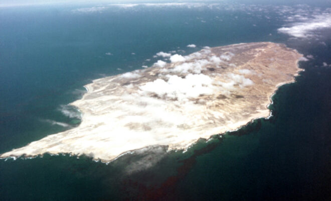
San Nicolas Island
4/19/2024
By Lesekker. FROM 1835 TO 1853, A Native American woman, stranded after the evacuation of her people, lived alone on San Nicolas Island. Her story inspired one of the most popular children’s novels ever written. Named Karana in Scot O’Dell’s Island of the Blue Dolphins, the Lone Woman of San Nicolas Island’s… SEE MORE
Developing Alternative Fisheries Management Scenarios to Respond to Climate Change
4/18/2024
By fisheries.noaa.gov. Seafood is a vitally important source of protein. Worldwide, more than 3 billion people rely on seafood as a significant part of their diets. The amount that we can sustainably fish and farm is based on historical catches and trends that have been monitored for decades. We need to understand… SEE MORE
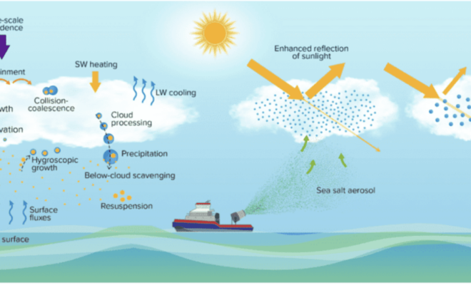
Scientists Detail Research to Assess Viability and Risks of Marine Cloud Brightening
4/17/2024
By research.noaa.gov. As the levels of greenhouse gases in the atmosphere continue to increase and climate change impacts become more costly, the scientific community is redoubling efforts to investigate the potential risks and benefits of artificially shading Earth’s surface to slow global warming. Marine cloud brightening (MCB) is one of… SEE MORE