Welcome to San Francisco, CA
San Francisco Harbor, home to San Francisco, one of America’s great cities, occupies the north portion of the peninsula forming the south entrance to San Francisco Bay. The 3-mile north shore of San Francisco from the Golden Gate Bridge to the main waterfront includes the Presidio of San Francisco; several yacht harbors; Government buildings and piers on Black Point; Aquatic Park; and Fisherman’s Wharf. Webcam of San Francisco.
Things to See & Do in San Francisco, CA
Golden Gate Park
One of the best places to visit in San Francisco, Golden Gate Park’s 1,017 has everything from museums, to sand dunes, to inspired gardens that will impress any horticulturalist. A wide variety of family-friendly places to visit include playgrounds, trails, picnic areas, and more. Attractions include the de Young Museum of Art, the Japanese Tea Garden, the San Francisco Botanical Garden, the Hall of Flowers, and people who love fishing shouldn’t miss Anglers Lodge.
The Presidio
The Presidio, one of the most dramatic places in San Francisco, is at the foot of the Golden Gate Bridge. It’s many attractions include access to the Golden Gate Bridge, several beaches and amazing overlooks with spectacular views, and Chrissy Field.
California Academy of Sciences
There is something for everyone at this awe-inspiring destination that includes an aquarium, planetarium, and natural history museum! Steinhard Acquarium has over 40,000 animals on display. The Osher Rainforest is a thriving indoor rainforest, with birds and butterflies. And for people who love the coast, take a dive into a coral reef through the incredible Expedition Reef exhibit. And finally, don’t miss the night life! NightLifeLIVE brings live music and art to the Academy once a month, on Thursday, to the Academy.
Fishermans’s Wharf
Fisherman’s Wharf is one of San Francisco’s most popular tourist destinations. It is a neighborhood that sits on the waterfront, a historic location that was once the main port of entry to the city. All types of people and goods arrived here, and many fishermen – especially Chinese and Italians – used the original Meigg’s Wharf and surrounding area to conduct their business. This history has endured as the fishing fleet that goes out of Fisherman’s Wharf is still active today. The neighborhood offers plenty of shopping, a multitude of restaurants with delicious seafood, the famous Ghiradelli Square and Ripley’s Believe It or Not museum, as well as several other fun and interesting places to visit. The neighborhood has a world-class fireworks display on July 4thevery year, and The Blue Angles show up during Fleet Week for an impressive air show.
Most visitors to the Fisherman’s Wharf neighborhood will want to stop by Pier 39 which offers a wide variety of activities for the family, including an aquarium, boat trips, free entertainment by talented local performers, and much more. One especially fun thing to see is the colony of Sea Lions who have moved into the area and can be seen lying around on the docks.
The Pier 39 Marina is also located here. Boaters can make advanced or same-day reservations by calling (415) 705-5436 or Marine radio VHF 16.
Alcatraz Island
In the middle of San Francisco Bay sits the compelling Alcatraz Island, a famous fort that became an infamous prison. Its rich history, and dramatic landscape will stir every imagination. This popular destination is can be reached by booking a boat trip to the island on Alcatraz Cruises.
San Francisco Maritime National Historical Park
For boat lovers and maritime history buffs, head down to the SF Maritime Museum (near Fisherman’s Wharf) where you’ll find impressive historic ships; a museum and research center; and the Aquatic Park Historic District. A chapel commemorating the “Lost Fishermen” of San Francisco can be found nearby on Pier 45.
San Francisco Marina & Small Craft Harbor
Home to one of the best established, and perhaps the oldest, marinas in the Bay Area, San Francisco Marina’s 35 acres also includes the popular Marina Green Park. The marina has 727 boat berths, including guest berthing for boats up to 50 feet, free pump out stations, and a fuel dock. Located 1.8 miles east of the Golden Gate Bridge with a west and east basin about 0.3 mile apart, San Francisco Yacht Harbor has depths of 8 to 12 feet to the berths. A light near the end of a point marks the north side of the entrance to west basin; a prominent stone tower is 0.2 mile west of the light. The east basin is protected on the north by a breakwater extending east from the west shore, and on the east by a pier of Fort Mason. The seaward end of the breakwater is marked by a light. east basin is entered between the breakwater light and the pier. The harbor accommodates about 700 boats in the west and east basins. Guest berths are available; transients should report to the harbormaster’s office on the south side of the west basin for berth assignment. Annual events include: the Escape from Alcatraz triathalon and Fleet Week.
South Beach Harbor Marina
South Beach Harbor, a great place for sailing and excellent views of the city, is located on the Embarcadero, ½ mile south of the Bay Bridge, on the inside of the Bay. This full-service marina includes 700 boat slips, a maritime center, a recreational and commercial dock, and the South Beach Park.
Greater Farallones National Marine Sanctuary
This incredible marine sanctuary protects over 3,295 square miles of the northern and central California coast. It is home to rich and diverse ocean ecosystem. The Greater Farallones Association, a non-profit that supports the sanctuary, provides educational programs and volunteer opportunities for citizen scientists.
Ferries in the SF Bay Area
- Golden Gate Ferry
This ferry runs between San Francisco’s Embarcadero, Sausalito, Larkspur, and Tiberon. - Blue and Gold Fleet
The Blue and Gold Fleet provides regular ferry service around San Francisco Bay, including Angel Island, Oracle Park, Harbor Bay, Oakland and Alameda, Richmond, Sausalito, Tiberon, South San Francisco, and Vallejo.
Weather in San Francisco
San Francisco enjoys a marine-type climate characterized by mild and moderately wet winters and by dry, cool summers. Winter rains (December through March) account for about three-fourths of the average annual rainfall of just over 19 inches (483 mm), and measurable precipitation occurs on an average of 13 days per month during this period. Snowfall occurs, but is infrequent. The greatest amount is 1.5 inches (38 mm) recorded in January 1962. Flurries have occurred in each month, December through March. There are frequent dry periods lasting well over a week. Severe winter storms with gale winds and heavy rains occur only occasionally. December is the month most likely to experience galesfollowed by January. Thunderstorms average five a yearand may occur in any month, but are usually very mild.
The summer weather is dominated by a cool sea breeze resulting in an average summer wind speed of nearly 13 knots. Winds are light in the early morning, but normally reach 17 to 22 knots in the afternoon, depending on location. Where topography and man-made structures funnel the winds, higher gusts may occur in those areas.
A sea fog, arriving over the station during the lateevening or night as a low stratified cloud, is anotherpersistent feature of the summer weather. This “high” fog, occasionally producing drizzle or mist, usually disappears during the late forenoon. Despite the morning overcast, summer days are remarkably sunny. On the average a total of only 15 days during the 4 months fromJune through September are classified as cloudy.
Daytime temperatures are held down both by the morning low overcast and the afternoon strengthening sea breeze, resulting in daily maximum readings averaging in the lower- to middle seventies (21.7° to 23.9°C) from May through August. However, during these months occasional “hot” spells lasting a few days are experienced without the usual “high” fog and sea breeze. September, when the sea breeze becomes less pronounced, is the warmest month with an average maximum of 73°F (22.8°C). Minimum temperatures during the summerare in the lower- to middle fifties (10.6° to 12.8°C). The all-time high temperature recorded at the InternationalAirport is 106°F (41.1°C) recorded in June 1961.
A strong temperature inversion with its base usually at a height of 1,500 feet (458) m) persists throughout thesummer. Inversions close to the ground are infrequentin summer, but rather common in fall and winter. As a consequence of these factors and the continued population and economic growth of the area, atmospheric pollution has become a problem of increasing importance.
Views of San Francisco
The skyline of the city of San Francisco is unmistakable, with several dominant landmarks: the 980-foot television tower supporting three antennas, the pyramid-shaped Transamerica Building, the Coit Tower on Telegraph Hill 3.4 miles east of the bay entrance, and the Bay Bridges with their freeway elevated approaches. Inside the bay, the Bank of America Building, the Bank of America Clock Tower, the clock tower at the south end of the San Francisco-Oakland Bay Bridge, the old Ferry Building with its 240-foot clock tower on the waterfront south of Pier 1, and the U.S. Coast Guard radar tower on Yerba Buena Island are prominent.
The Ferry Building, terminal of many ferry boats, also houses the San Francisco Port Authority offices, the offices of the Marine Exchange, Inc., and the many offices and exhibits of the World Trade Center.
Boating in San Francisco, CA Map View
San Francisco Bay, the largest harbor on the Pacific coast of the United States, is more properly described as a series of connecting bays and harbors of which San Francisco Bay proper, San Pablo Bay, and Suisun Bay are the largest. Depths of 29 to 40 feet are available for deep-draft vessels to San Francisco, Oakland, Alameda, Richmond, and Redwood City in San Francisco Bay proper; to Stockton on the San Joaquin River; and to Sacramento through the lower Sacramento River and a deepwater channel. Much of the local navigation is by light-draft vessels and barges.
San Francisco, one of America’s great cities, occupies the N portion of the peninsula forming the S entrance to the bay. The 3-mile N shore of San Francisco from the Golden Gate Bridge to the main waterfront includes the Presidio of San Francisco; several yacht harbors; Government buildings and piers on Black Point; Aquatic Park; and Fisherman’s Wharf. The charted recreation area extending along this shore is intended primarily for use by recreation vessels.
High-speed commuter ferries frequently operate in central/south San Francisco Bay and San Pablo Bay. Concentrations of these ferries are highest around the San Francisco Ferry Building (37°47’45″N., 122°23’35″W.) where most central bay routes terminate. Mariners are cautioned when transiting these waters that ferries may maneuver quickly when approaching and departing the dock.
The east shore of San Francisco Bay proper is low except for rolling grassy hills in the north part and extensive marshes intersected by numerous winding sloughs in the south part. The west shore north of the entrance is much bolder than the east shore where there are only a few stretches of low marsh. Below San Francisco, marshes and flats intersected by numerous sloughs extend to thesouth end of the bay.
Entering San Francisco Bay
The entrance to San Francisco Bay is through Gulf of the Farallones and the narrow Golden Gate. The gulf extends from Point San Pedro on the south for 34 miles to Point Reyes on the north, and has a greatest width of 23miles from Farallon Islands on the west to the mainland.
In clear weather many prominent features areavailable for use in making San Francisco Bay, but inthick weather the heavy traffic and the currents, variable in direction and velocity, render the approaches difficultand dangerous. Point San Pedro, Montara Mountain,Farallon Islands, Mount Tamalpais, and Point Reyes areprominent in clear weather and frequently can be seen when the land near the beach is shut in by low fog or haze. Radar navigation on the approach to San Francisco Bay is not difficult because of the numerous distinctive and high relief of targets available. Southeast Farallon Island, Point Reyes, Double Point, Bolinas Point, Duxbury Point, Rocky Point, Point Bonita, San Pedro Rock and Point, and Pillar Point are good radar targets.
The first 8 miles of coast from Point San Pedro to San Francisco Bay entrance consists of whitish bluffs that reach a height of 600 feet, then a 3-mile sand beach extends to the entrance. Shelter Cove, on the north side of Point San Pedro, provides shelter from the east storms with good holding ground in gray sand bottom. San Pedro Rock, close to the point and 100 feet high, also gives some protection in south weather.
The Greater Farallones National Marine Sanctuary has been established to protect and preserve the natural, cultural and historical resources in the waterssurrounding the Farallon Islands, including offshore ofthe Marin and Sonoma county coasts to Bodega Head. The sanctuary boundary includes the estuarine waters of Bolinas Lagoon, Tomales Bay, Estero Americano, Estero de San Antonio and Bodega Bay but not Bodega Harbor. Visitor use is encouraged for boating, diving, snorkeling,fishing, swimming, kayaking and wildlife viewing.
Farallon Islands, 23 miles west of San Francisco Bay entrance, are rocky islets extending northwest for 7 miles. Southeast Farallon, the largest of the group, actually consists of two islands separated by a narrow impassable gorge. The larger east island is pyramidal in shape and 350 feet high; a small-boat landing is on the south side.
Farallon Light (37°41’57″N., 123°00’07″W.), 358 feet above the water, is shown from a white conical tower on the highest peak of the island. Dwellings are on the lowland on the south side of the island. Fisherman Bay, just north of Farallon Light, is somewhat protected by several rocky islets on the west side and affords anchorage in 8 fathoms in the outer part. Boats can be landed on a small sand beach on the largest islet.
Hurst Shoal, 0.6 mile southeast of Farallon Light, is covered 22 feet and breaks only in heavy weather.
Middle Farallon, 2.3 miles northwest of the light, is a 20-foot single black rock 50 yards in diameter; several rocks covered 5 to 7 fathoms are within 0.7 mile south and southwest of it.
North Farallon, 6.5 miles northwest of Farallon Light, consists of two clusters of bare precipitous isletsand rocks from 91 to 155 feet high, 0.9 mile in extent, and 0.3 mile wide; submerged rocks surround them.
Fanny Shoal, 9.8 miles northwest of Farallon Light and 14 miles southwest of Point Reyes, is 2 miles in extent and covered 2 to 30 fathoms. Noonday Rock, covered 3 1/4 fathom, rises abruptly from 20 fathoms and is the shallowest point of the shoal; it is the principal danger in the north approach to San Francisco Bay. A lighted bell buoy is about 0.7 mile west of the rock. Noonday Rock derives its name from the clipper ship that struck it in 1862 and sank within an hour, in 40 fathoms.
Cordell Bank, 27 miles northwest of Farallon Light and 20 miles west of Point Reyes, is about 6 miles long and 3 miles wide; the bank is covered 20 to 40 fathoms, but depths increase rapidly outside it.
The Cordell Bank National Marine Sanctuary has been established to protect and conserve the special, discrete, highly productive marine area of Cordell Bank and its surrounding waters and to ensure the continued availability of the areas ecological, research, educational, aesthetic, historical, and recreational resources.
Aquatic Park, 2.6 miles E of the Golden Gate Bridge, is a recreation area protected on the W by a curved pier extending out from Black Point and on the E by a pier that berths historic ships of the National Maritime Museum. The basin is closed to power vessels, and other vessels must stay offshore away from buoys marking a swimming area. The speed limit is 3 knots. Depths of 9 to 16 feet are inside the basin. Small craft can find anchorage in about 13 feet. Permission to anchor for more than 24 hours must be obtained from the Aquatic Park Ranger Station.
San Francisco Approach Lighted Whistle Buoy SF (37°45’00″N., 122°41’34″W.) is 9 miles west-southwest of San Francisco Bay entrance. The buoy is red and white and is equipped with a racon.
San Francisco Bar, a semicircular shoal with depths less than 36 feet, is formed by silt deposits carried to the ocean by the Sacramento and San Joaquin River systems. The bar extends from 3 miles south of Point Lobos to within 0.5 mile of Point Bonita off the southern coast of Marin Peninsula; the extreme outer part is about 5 miles west-southwest of San Francisco Bay entrance.Potatopatch Shoal, the north part of the bar on Four Fathom Bank, has depths from 24 to 28 feet.
Warning: Very dangerous conditions develop over the bar whenever large swells, generated by storms far out at sea, reach the coast. A natural condition called shoaling causesthe large swells to be amplified and increase in height whenthey move over the shallow water shoals. This piling up of the water over the shoals is worsened during timeswhen the tidal current is flowing out (ebbing) throughthe Golden Gate. Outbound tidal current is strongest about 4 hours after high water at the Golden Gate Bridge and attains a velocity in excess of 6 knots at times. The incoming large swells are met by outbound tidal current causing very rough and dangerous conditions over the bar. Steep waves to 20 or 25 feet have been reported in the area. Mariners should exercise extreme caution as the bar conditions may change considerably in a relatively short period of time.
The most dangerous part of the San Francisco Bar is considered to be Four Fathom Bank. Bonita Channel, between the shoal and the Marin coast, can also become very dangerous during large swell conditions. The safest part of the bar is the Main Ship Channel through the center of the bar. But even that area can be extremely dangerous when the tidal current is ebbing.
Golden Gate, the passage between the ocean and San Francisco Bay, is 2 miles wide at the west end between Point Bonita and Point Lobos, but the channel is reduced in width to 1.5 miles by Mile Rocks and to less than 0.7 mile by the Golden Gate Bridge pier. Depths in the passage vary from 108 feet to over 300 feet.
Point Lobos, the south entrance point to the Golden Gate, is high, rocky and rounding with black rugged cliffs at its base. A large water tank is on the summit. The Cliff House is near the south part of the west face of the point; high and rocky Seal Rocks are just offshore.
Mile Rocks, 700 yards northwest of the sharp projecting point off Lands End on the north face of Point Lobos, are two small 20-foot-high black rocks about 100 feet apart. Mile Rocks Light (37°47’34″N., 122°30’37″W.), 49 feet above the water, is shown from anorange and white horizontally banded tower on the outer and larger rock; a sound signal is at the light.
Passage between Mile Rocks and Point Lobos should not be attempted because of the covered and visible rocks extending over 300 yards from shore and the rocks covered 6 and 14 feet south of Mile Rocks Light.
The south shore of the Golden Gate extends in a gentle curve northeast for 2 miles to Fort Point, forming a shallow bight called South Bay. The cliffs rise abruptly from narrow beaches, except near the middle of the bight where a valley terminates in a sand beach 0.3 mile long. Sailing craft are sometimes obliged to anchor here when becalmed, or when meeting an ebb current, to avoid drifting onto Mile Rocks, but the anchorage isuncomfortable and it is difficult to get underway from it.
Fort Point projects slightly from the high cliffs and is marked by a square red brick fort with a stone seawall in front. The fort, which is obscured by the south end of the Golden Gate Bridge, and 29 acres of land adjacent to the fort are part of the Fort Point National Historic Site.The fishing wharf at Fort Point is unsafe for mooringbecause of surge conditions.
The north shore of the Golden Gate is bold and rugged, with reddish cliffs rising abruptly from thewater’s edge to over 600 feet.
Point Diablo, 1.4 miles east of Point Bonita, rises abruptly from a 0.1-mile sharp projection to a height of over 200 feet with deep water on all sides. A light is shown from a white house on the end of the point; a sound signal is at the light.
The mile-long shore between Point Diablo and Lime Point forms a shallow bight with steep cliffs. Near the middle of the bight the cliffs are cut by a narrow valley which ends in a low beach at the shore.
Lime Point, 2.5 miles east of Point Bonita, is high and precipitous, and rises abruptly to a height of nearly 500 feet in less than 0.3 mile. A light is shown from a pole at the end of the point.
Golden Gate Bridge, crossing the Golden Gate from Fort Point to Lime Point, has a clearance of 225 feet at the center of the 4,028-foot-wide channel span between the 740-foot-high supporting towers; the least clearance of 211 feet at the south pier. Two scaffolds located in the main navigation channel span and one scaffold in the southern span reduce vertical clearance by approx 12 feet and are lighted at night with red lights. The Golden Gate Bridge District will move the scaffolding upon 48 hours advance notice for the passage of vessels. Scaffolding is moved to the piers when not in use. Mariners should contact the Golden Gate Bridge at 415–923–2230. The center of the span is marked by a fixed green light with three fixed white lights in a vertical line above it and by a private sound signal and racon; a private light and sound signals are on the south pier. When approachingGolden Gate Bridge in the eastbound traffic lane in fog, channel Buoy 2 sometimes provides a radar image that indicates the location of the south pier of the bridge. Aero obstruction lights mark the tops of the bridge towers.
Boating Around the City of San Francisco
The charted recreation area extending along this shore is intended primarily for use by recreation vessels. It should not be utilized by vessels 300 tons or more forthrough passage or for any other purpose, except in case of emergency or special circumstances.
Alcatraz Island, 2.5 miles east of the Golden Gate Bridge, is one of the leading marks in entering San Francisco Bay. The small island is 148 feet high and has many buildings on it. Near the northwest end of the island is a water tower, which is reported to be usually the only landmark visible when that area is in fog. Alcatraz Light (37°49’34″N., 122°25’20″W.), 214 feet above the water, is shown from a gray, octagonal pyramidal tower on the southeast part of the island. A mariner radio activated sound signal, on the northwest end of the island, isinitiated by keying the microphone five times on VHF-FM channel 81A.
A rock awash is 125 yards west of the northwest endof Alcatraz Island. A lighted bell buoy is 150 yards westof the rock. The rocks and tide pools, which extend about 100 feet from the south tip of the island, are reported to cover at high water.
Mariners are advised that surveys indicate shoaling tends to build to the northwest of the disposal area southof Alcatraz Island and caution should be used in the area.A shoal oriented southwest to northeast with a least depth of 32 feet extends off the east shore of the island.
Alcatraz Island, a part of the Golden Gate NationalRecreation Area, is administered by the Department ofInterior’s National Park Service. Federal regulations require that prior permission to land at Alcatraz, or to berth vessels at Fort Mason, Black Point, and Aquatic Park must be obtained from the General Superintendent, Golden Gate National Recreation Area, Fort Mason, San Francisco, CA 94123.
A passenger ferry, which operates frequently, uses adock on the southeast side of the island. In 1979, 28 feetwas reported off the dock.
Yerba Buena Island, 345 feet high and 2.5 milessoutheast of Alcatraz Island, is of small extent, irregularin shape, and covered with a scrubby growth of trees. On its summit is a former lookout tower and the Coast Guardoperated San Francisco Vessel Traffic Service OperationCenter and radar antenna site. San Francisco Coast Guard Station is on the east side of the island.
Treasure Island is a low filled area north of and connected by a causeway to Yerba Buena Island. Built originally for the San Francisco International Exposition of 1939-40, Treasure Island now belongs to the city ofSan Francisco. A light is on the north end of the island and a shoal, covered 15 feet, is off the north end of the island.
When the prevailing west winds are blowing, deep- draft vessels proceeding to the berthing area on the eastside of the island may have extreme difficulty making the90° turn from the narrow channel between the 30-footcurves southeast of Yerba Buena Island.
Naval restricted areas, are off the north end ofTreasure Island and between this island and Yerba Buena Island. A restricted area surrounds the Coast Guard Station off the east side of Yerba Buena Island.
The San Francisco-Oakland Bay Bridge, one of the longest bridges in the world, crosses the bay fromRincon Point in San Francisco to Yerba Buena Island,thence to Oakland. Clearances given in the San Francisco- Oakland Bay Bridge table are approximate; they may bereduced by several feet due to heavy traffic on the bridgeand prolonged periods of extremely high temperature, and as much as 10 feet under extreme conditions.
The Port of San Francisco is the oldest on the Pacificcoast. Though primarily a general cargo port, grain, bulk liquids, containers, newsprint, automobiles, bananas, copra, cotton, and other commodities are handled here. San Francisco is a popular port of call for passenger vessels on regular scheduled and special cruises.
Dangers
Anita Rock, 1.1 miles east of Fort Point and 300 yards from shore, is covered 3 feet and marked by a light.
There are several rocky patches with depths of 33 to35 feet west and northwest of Alcatraz Island that must beavoided by deep-draft vessels. The northwesternmost of these shoals is Harding Rock, marked by a lighted buoy equipped with a racon.
Blossom Rock, covered 39 feet and marked on the west side by a lighted bell buoy, is about 1 mile southeastof Alcatraz Island. Another rock, covered 41 feet, is 0.3mile south of Blossom Rock.
The Trans-Bay Tube of the Bay Area Rapid Transit District crosses San Francisco Bay from the vicinity of the Ferry Tower to Oakland. Mariners are prohibitedfrom dropping or dragging anchors when in the vicinity of the tunnel crossing.
Heavy tide rips occur in the vicinity of Alcatraz Island.
Currents
Inside the Golden Gate the flood current sets into all parts of the bay and causes swirls from the Golden Gate as far east as Alcatraz and Angel Islands and through Raccoon Strait, north of Angel Island. The ebb current, inside the Golden Gate, is felt first along the south shore. In the Golden Gate, the average duration of the ebb stream is somewhat greater than that of the flood. The Sacramento and San Joaquin Rivers have weak floodcurrents during periods of freshets.
The San Francisco-Oakland Bridge has large current eddies near the foundation piers that cause ships to sheer off course.
Strong currents due to heavy spring runoffs have been reported along the San Francisco waterfront between pier 39 (37°48’36″N., 122°24’38″W.) and pier 94 (37°44’34″N., 122°22’13″W.)
Ferries in San Francisco, CA
High speed and traditional ferries frequently operate in central/south San Francisco Bay and San Pablo Bay. Concentrations of these ferries are highest around the SanFrancisco Ferry Building (37°47’45″N., 122°23’35″W.) where most central bay routes terminate. Mariners are cautioned when transiting these waters that ferries may maneuver quickly when approaching and departing the dock. Departing ferries from the Ferry Building often back away from the dock. Charted ferry routes can be seen on applicable charts of the area; however, mariners are cautioned that these ferries may deviate from their routes due to inclement weather, traffic conditions, navigational hazards, or other emergency conditions. The Safety Committee also recommends that recreational and fishing vessels keep a close lookout when near ferry routes, and avoid ferry routes whenever possible. For additional information, see the San Francisco Marine Exchange.
In San Francisco Bay charted ferry routes run north and south in North Channel (east of Angel Island) and in the Precautionary Area just east of Alcatraz Island. They generally run east and west in the waters between Alcatraz Island and Angel Island. The routes cross each other in the Precautionary Area (37°49’30″N., 122°24’10″W.) and about 1.2 miles south of the Richmond-San RafaelBridge. In these areas all vessels should maintain a close watch for ferries. In San Pablo Bay, ferry routes runin both directions just south of Pinole Shoal Channel between the Richmond-San Rafael Bridge and MareIsland; one route runs east of East Brothers Island. Many ferries also operate between San Francisco’s north shore,Alcatraz and Sausalito/Tiburon. These ferries do not run along charted ferry routes. They too may back away when departing San Francisco docks and may maneuver rapidly when approaching San Francisco.
The San Francisco Harbor Safety Committee, in conjunction with the Coast Guard, has established a Ferry Traffic Routing Protocol for: the area surrounding the Ferry Building terminal along the waterfront of San Francisco, the waters of central San Francisco Bay, and the waters of San Pablo Bay. The protocol is intended to increase safety in the area by reducing traffic conflicts and, while not compulsory, the guidelines set forth in the protocol are strongly recommended.
Coast Guard in San Francisco Bay
Golden Gate Coast Guard Station is about 0.4 mile north-northeast of the bridge at the entrance to Horseshoe Bay. Station Golden Gate is participating in the Coastal Weather Display Program. A 35-foot flag pole is locatednear the south end of the Coast Guard Station, visible to mariners exiting San Francisco Bay. Coastal warning flags will be flown from one hour before sunrise to one hour after sunset.
Weather flags are flown only at select Coast Guard stations to supplement other weather notification sources. Light signals corresponding to these flags are not displayed at night. In all cases mariners should rely uponNational Weather Service broadcasts as their primary source of government provided weather information.
Sector Office San Francisco is located on YerbaBuena Island. San Francisco Coast Guard Air Station is at San Francisco International Airport. A Coast Guard base and station are on the east side of Yerba Buena Island.
The Marine Exchange of the San Francisco Bay region reports and records all Golden Gate ship arrivals and departures and conducts communications to serve the bay area commercial traffic. The station can be called 24 hours a day for relay of messages and other marine related services on VHF-FM channels 10 and 18. The station also monitors channels 13 and 16. The ship spotting station is located in Building B, Fort Mason, about 2.5 miles east of the Golden Gate Bridge.
Boating Resources for San Francisco, CA
Important Contacts
Harbormaster in San Francisco, CA
Charts, Navigation, & Guides
Online Nautical Chart for San Francisco, CA
Pilot Guide Info for San Francisco, CA
Important Locations & Services
Weather Conditions & Forecasts
Check Tides in San Francisco, CA
Print a Tide Chart for San Francisco, CA
Other Resources
FEATURED CONTENT

In The Zone: The Sabre 51 Salon Express
By US Harbors When Sabre Yachts completed construction of hull number 200 of its 48 Salon Express model, more than half the crew who built it had also worked on hull number one. The average tenure on that line was 12 years, and they produced a yacht that proved to… Learn More
Coastal News Updates See All

Going With The Flow: Visualizing Ocean Currents with ECCO
7/28/2026
By James Riordon, science.nasa.gov. Historically, the ocean has been difficult to model. Scientists struggled in years past to simulate ocean currents or accurately predict fluctuations in temperature, salinity, and other properties. As a result, models of ocean dynamics rapidly diverged from reality, which meant they could only provide useful information… SEE MORE
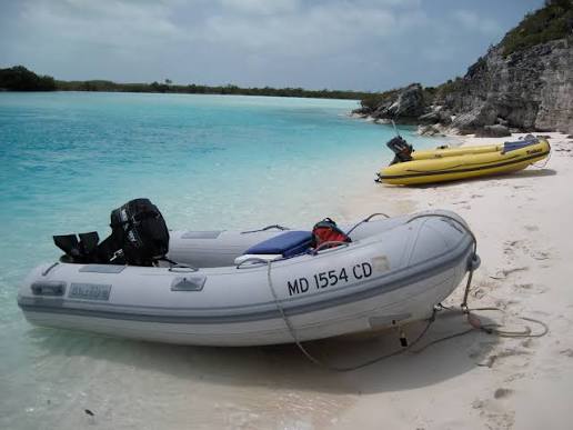
An Easy Fix for Faded Boat Registration Numbers on Your Dinghy
7/27/2026
By Arnie Hammerman, best4boats.com. If your dinghy’s registration numbers are peeling, fading, or falling off entirely, you’re not alone — and there’s a better solution than trying to paint or stick individual decals back on. A hands-on gear column from Best4Boats walks through a practical, long-lasting fix using custom-made number… SEE MORE
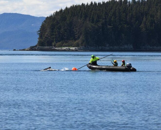
Humpback Whale Successfully Freed from Entanglement in Endicott Arm
7/26/2026
By fisheries.noaa.gov, fisheries.noaa.gov. The Tracy Arm-Fords Terror wilderness, located 50 miles south of Juneau, Alaska, features a pair of steep glacial fjords: Tracy Arm and Endicott Arm. While remote, the waters in this area see steady vessel traffic, ranging from massive cruise ships and small charter boats to commercial fishing… SEE MORE