Information about Tides & Weather
We at US Harbors work hard to provide the most comprehensive view of coastal conditions as possible. Those of you who spend time on and/or around the water know how important it is to keep up to date weather and tides, and how indivisible they are when it comes to life on the coast. We hope that by providing you with this holistic, hyper-local view of your conditions and community, you can make the best decisions possible.
Tides and weather sometime seem almost magical, and there is a host of interesting folklore around the both of them. We are always interested in these stories, but take our responsibilities seriously in providing the most accurate and up-to-date scientific information as possible. We get questions from our users all the time and are providing a short FAQ here to answer some of them. If you have something you think should be added please contact us.
All About Tides
Q: What are our tide high/low measurements based on?
A: The baseline for giving how high or low the tides are is called the MLLW, or Mean Lower Low Water. This is the average low water height for a complete 19-year Metonic Cycle (also known as the National Tidal Datum Epoch) – basically the time it takes for a high-tide to occur at exactly the same time and date. This number is what is used on nautical charts. So if the low tide has a negative number then you know the tide is going to be further out than normal.
Q: Why are there blank cells in the tide chart?
A: Sometimes you might notice in our tide charts that the high/low for a given date is not there. The reason for this is the fact the tides don’t quite fit into a daily cycle, and actually average 24 hours and 54 minutes between complete cycles. So those ‘missing’ cells are where the tide time has jumped into the next day.
Q: Why do some cells show AM or PM, but not others?
A: Similar to the answer above, there are instances where 2 high tides occur in one 12-hour period. If that is the case, the second time will be in the second time column (PM) but will say AM so you know it is in same period as the first time of the day. These are rare, depending on the layout of the harbor and surrounding geographically features.
Q: How do we calculate “King Tides”?
A: The truth is we don’t predict King Tides in our tide charts. ‘King Tides’ refer to the highest tide of the year. There are many factors that can increase the height of the tide the are not caused by the predictable phases of the moon, which our tide charts are based on. Things like flooding and river surges can change the height of the tide on any given day. This is often true when snow melt is running off the mountains and hence they are often also known as ‘Spring Tides’. Each lunar cycle there are perigean high tides, when the moon is at its closest. The tide will only increase by a few inches, but when it coincides with the conditions mentioned above it can cause King Tides.
Q. How do the currents affect the tides?
A: Many mariners use a general rule that says that slack water (no movement of water in any direction) occurs at high tide and low tide. However there are exceptions depending on the location and its currents.
There are other factors that affect the appearance of slack water:
- Wind driven currents can alter the timing of slack water.
- Changes in river flow due to rain and runoff (or lack of it). – Changes in the freshwater river flow of only 1/4 of a knot can shift times of slack water by as much 30-45 minutes.
There is no consistent relationship between tides and currents; and even at the same location, that relationship can be significantly different on two different days, or even two different parts of the same day.
A common rule regarding slack water and high tide is a reasonable approximation of when high or low tides may occur; with an error of up to +/- 90minute, and possibly up to 2 hours, in some cases.
Q: What are the best resources for learning more about tides?
A: There are several really great organizations that have helpful information on tides. Here are our favorite:
- https://www.noaa.gov/education/resource-collections/ocean-coasts-education-resources/tides
- https://tidesandcurrents.noaa.gov/products.html
- https://www.ntslf.org/about-tides/tides-faq
- https://tidesandcurrents.noaa.gov/datum_options.html
We also have several articles here that are interesting and helpful:
- https://www.usharbors.com/2020/12/are-tides-and-waves-the-missing-piece-of-the-green-energy-puzzle/
- https://www.usharbors.com/2020/10/how-high-water-levels-could-impact-you/
- /2019/04/how-to-fish-the-tides-use-tides-currents-and-water-movement-to-your-advantage/
- /2019/04/myth-busting-the-tide/
- /2018/10/amazing-facts-about-the-tide/
- /2018/08/jonathan-white-author-of-tides-the-science-and-spirit-of-the-ocean-to-attend-maine-boat-home-show/
- /2012/01/tides-101-the-view-from-space/
All About Weather
Q: How do you collect all this weather data?
A: We work with a variety of data sources to provide our users with the most comprehensive, timely, and accurate picture of conditions on the coast.![]() However, like other weather websites, the National Oceanic and Atmospheric Administration (NOAA.gov) provides the majority of our weather data.
However, like other weather websites, the National Oceanic and Atmospheric Administration (NOAA.gov) provides the majority of our weather data.
Q: What wind speeds are used to determine the Marine Forecast warnings?
Marine forecasts issue different types of warnings at various wind speeds. They used to use storm flag symbols to indicate these warnings, but these are no longer in general use. ![]()
| Small Craft Warning 21-38 mph (18-33 kts) |
Gale Warning 39-54 mph (34-47 kts) |
Storm Warning 55-73 mph (48-63 kts) |
Hurricane Warning 74+ mph (64+ kts) |
Q: What are the various wind ‘scales’ and how do they work?
A: The Beaufort Scale, devised in 1805 by Sir Francis Beaufort (1774-1875), is a system for estimating wind strengths without the use of instruments, based on the effects wind has on the physical environment. The behavior of smoke, waves, trees, etc., is rated on a 13 point scale of 0 (calm) to 12 (hurricane).![]()
W- Small ripples |
|||
Breeze |
W- Small wavelets, wind fills sail |
||
W- Large wavelets, sailboats heel |
|||
W- Working breeze, sailboats at hull speed |
|||
W- Numerous whitecaps, time to shorten sails |
|||
W- Whitecaps everywhere, sailboats head ashore, large waves |
|||
W- Much bigger waves, some foam, sailboats at harbor |
|||
Gale |
W- Foam in well marked streaks, larger waves, edges of crests break off |
||
Gale |
W- High waves, dense spray, visibility affected |
||
Gale |
W- Very high waves, heavy sea roll, surface white with spray and foam, visibility impaired |
||
W- Exceptionally high waves, small to medium ships obscured, visibility poor |
|||
W- Waves 40+’, air filled with foam and spray, visibility restricted |
Herbert Saffir, a consulting engineer in Coral Gables, Fla., and Robert Simpson, who was then director of the National Hurricane Center, developed the scale in the early 1970s. It was updated in 2010 removing references to “storm surge.” Surge information for specific storms is now included in local hurricane statements.![]()
Winds 74-95 mph (64-82 kt or 119-153 km/h)
Very dangerous winds will produce some damage: Well-constructed frame homes could have damage to roof, shingles, vinyl siding and gutters. Large branches of trees will snap and shallowly rooted trees may be toppled. Extensive damage to power lines and poles likely will result in power outages that could last a few to several days. Hurricanes Allison of 1995 and Danny of 1997 were Category One hurricanes at peak intensity.
Category Two Hurricane:
Winds 96-110 mph (83-95 kt or 154-177 km/h)
Extremely dangerous winds will cause extensive damage: Well-constructed frame homes could sustain major roof and siding damage. Many shallowly rooted trees will be snapped or uprooted and block numerous roads. Near-total power loss is expected with outages that could last from several days to weeks. Hurricane Bonnie of 1998 was a Category Two hurricane when it hit the North Carolina coast, while Hurricane Georges of 1998 was a Category Two Hurricane when it hit the Florida Keys and the Mississippi Gulf Coast.
Category Three Hurricane:
Winds 111-129 mph (96-112 kt or 178-208 km/h)
Devastating damage will occur: Well-built framed homes may incur major damage or removal of roof decking and gable ends. Many trees will be snapped or uprooted, blocking numerous roads. Electricity and water will be unavailable for several days to weeks after the storm passes. Hurricanes Roxanne of 1995 and Fran of 1996 were Category Three hurricanes at landfall on the Yucatan Peninsula of Mexico and in North Carolina, respectively.
Category Four Hurricane:
Winds 130-156 mph mph (113-136 kt or 209-251 km/h)
Catastrophic damage will occur: Well-built framed homes can sustain severe damage with loss of most of the roof structure and/or some exterior walls. Most trees will be snapped or uprooted and power poles downed. Fallen trees and power poles will isolate residential areas. Power outages will last weeks to possibly months. Most of the area will be uninhabitable for weeks or months. Hurricane Luis of 1995 was a Category Four hurricane while moving over the Leeward Islands. Hurricanes Felix and Opal of 1995 also reached Catgeory Four status at peak intensity.
Category Five Hurricane:
Winds greater than 157 mph (137 kt or higher or 252 km/h or higher)
Catastrophic damage will occur: A high percentage of framed homes will be destroyed, with total roof failure and wall collapse. Fallen trees and power poles will isolate residential areas. Power outages will last for weeks to possibly months. Most of the area will be uninhabitable for weeks or months. Hurricane Mitch of 1998 was a Category Five hurricane at peak intensity over the western Caribbean. Hurricane Gilbert of 1988 was a Category Five hurricane at peak intensity and is the strongest Atlantic tropical cyclone of record.
 Source: National Oceanic and Atmospheric Administration (NOAA)
Q: How is ‘feels like’ temperature different from ‘wind chill’?
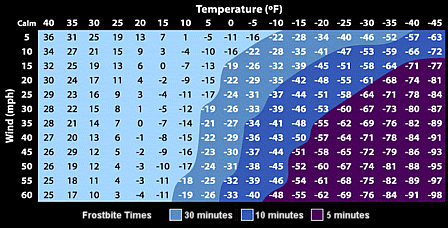
A: Forecasters rarely refer to wind chill any more as they now use the more accurate ‘feels like’ temperature to help us know how the weather will really affect us. ‘Feels like’ uses both humidity and wind speed to determine how hot or cold the air feels to humans and animals. Wind chill looks at only the wind speed variable to determine how much colder we might feel when the wind is cooling our bodies by driving heat away from our skin. Wind chill calculations are based on the rate of heat loss from exposed skin caused by combined effects of wind and cold.
If you want to know how cold it needs to ‘feel’ before you get frostbite, we have this quick chart. Cold winds and humid air can combine to give people significant chills.
Wind Chill/Frostbite Chart![]()