Skip to content
US Harbors
  • Already a Member?
  • Login
  • US Harbors
  • Login
  • Harbormaster Day
  • Best Harbor Contest
  • Contact Us
  • Tides
  • Weather
  • Flooding
  • Stories
    • Boating
    • Coastal Life
    • Fishing
    • Marine Economy
    • Ocean Science
    • Weather & Tides
Login

Tag: Ocean Mapping

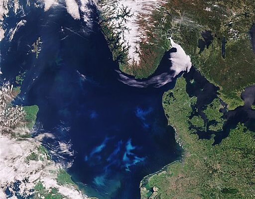
Contains modified Copernicus Sentinel data 2022, CC BY-SA 3.0 IGO ,North_Sea_bloom via Wikimedia Commons

Breathing Life into the Ocean

  • Coastal News
  • Ocean Science
12/15/2022 - By earthobservatory.nasa.gov From global to regional scales, images from satellites portray the dynamic beauty of the world’s oceans. Each view reveals something unique, from the seasonal pulses of life to the colorful signature of phytoplankton blooms. Almost all life in the ocean depends on tiny photosynthetic organisms known as phytoplankton.… SEE MORE
  • coast
  • Ocean Awareness
  • Ocean Exploration
  • Ocean Mapping
  • Science
https://www.westcoast.fisheries.noaa.gov

NOAA Ocean Exploration Meets Major Mapping Milestone

  • Boating
  • Coastal News
  • Weather & Tides
11/20/2021 - Two million square kilometers. Or 772,204 square miles. That’s more than one quarter the size of the contiguous United States. And it’s the area of seafloor mapped by NOAA Ocean Exploration using the modern, high-resolution multibeam sonar system aboard NOAA Ship Okeanos Explorer since the ship was commissioned in 2008. Why We Map There’s so… SEE MORE
  • Health
  • NOAA
  • Ocean Mapping
  • Safety
https://coralreef.noaa.gov/aboutcrcp/news/featuredstories/feb15/coraletiquette.html

Researchers Complete First-ever Detailed Map of Global Coral

  • Coastal News
  • Ocean Science
9/10/2021 - By Caleb Jones. HONOLULU (AP) — Researchers have completed a comprehensive online map of the world’s coral reefs by using more than 2 million satellite images from across the globe. The Allen Coral Atlas, named after late Microsoft co-founder Paul Allen, will act as a reference for reef conservation, marine… SEE MORE
  • Allen Coral Atlas
  • Coral
  • Environment
  • Ocean Mapping

NOAA Issues New Strategy for Ocean Mapping

  • Boating
  • Coastal News
  • Fishing
8/18/2020 - Last week, NOAA’s Office of Coast Survey released the Mapping U.S. Marine and Great Lakes Waters: Office of Coast Survey Contributions to a National Ocean Mapping Strategy. This report is part of NOAA’s ongoing commitment to meet core surveying and nautical charting mandates while supporting broader needs to fill gaps in… SEE MORE
  • NOAA
  • Ocean Mapping
Sign Up

SIGN UP FOR OUR NEWSLETTER

Coastal flooding reports, travel ideas, news from harbors around the country, and the latest on ocean conservation trends.

Subscribe

Find tide charts and weather for 1,400 harbors across the U.S.

US Harbors

About US Harbors

Contact Us


Advertise with Us

Terms & Conditions


Tide & Weather FAQs

Help FAQ

“Best Harbor” Contest

National Harbormaster Day

Reach over 12 million boaters and people who love the coast:
Contact our sales team for an advertising quote.
Tides, Weather & Local Knowledge is a registered trademark of US Harbors LLC.

  • Facebook
  • YouTube
  • Instragram
US Harbors ® USHarbors.com
  • Terms & Conditions
  • Privacy Policy
  • My Personal Information
Copyright © 2026 US Harbors

We respect your privacy

This website uses cookies to ensure you get the best experience. Learn more

Your Privacy Choices