Severe Weather Preparedness: The Human Element is Key
Posted
Last Updated
By David Cannon, Director of Yacht Operations/Meteorologist WRIWX.com.
The science of Meteorology and more particularly weather forecasting is an ever-evolving field. Let’s take for example its “infancy” … tracking changes and trends in weather through the use of weather instruments to collect data gave way to the use of radar during the 1950s. This was later followed by the birth of the “satellite age” where satellites in the 1960s allowed forecasters to determine real-time data and generate forecasts from information that is now constantly at their disposal.
During the latter part of the 20th century, computer models entered the mix, reducing the limitations of forecasters and allowing them to provide predictions days, even weeks in advance. In fact, numerous forecast models are now easily obtained through the internet that allows users to get a feel, for the timing, intensity, and track of weather features. Furthermore, higher resolution models then allowed for a more “refined product” that takes into account local topography and diurnal effects. Mobile apps put severe and tropical weather preparedness literally in the palm of your hands, making weather information even easier to access, and affordable, with many free apps available.
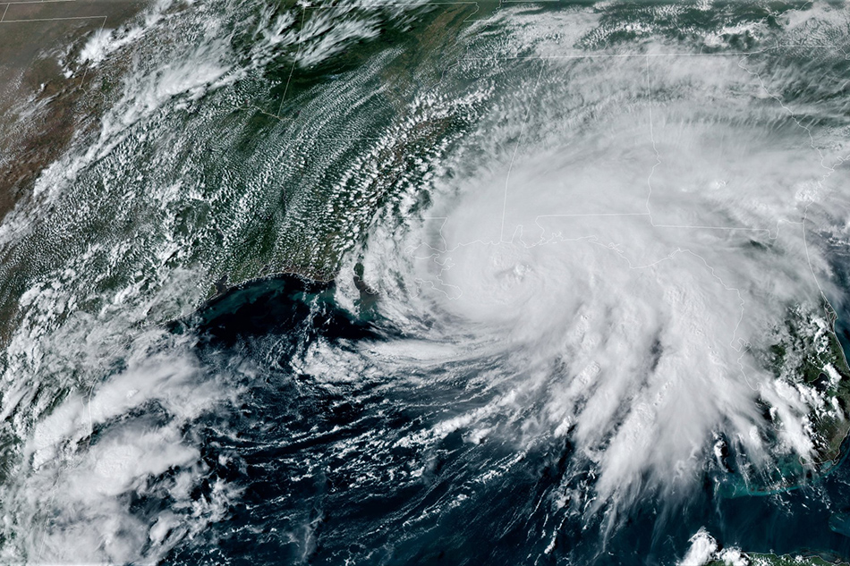
So, with that said does a high-tech computer model make a non-exact science exact? It seems too good to be true, right? One only needs to go to the internet or a mobile device, view a few maps, and you’re all set. Well before you say yes, let’s look at the recent example of Hurricane Sally, which brought flooding rains to portions of the U.S. Gulf Coast earlier this month:
- Computer model projections showed nothing more than a broad area of low pressure during the formative stages of development on 11 September off the Southeast Coast of Florida. However, real-time surface observations and satellite imagery indicated the development of a closed surface low and falling pressures. This combined with the warm Gulf Stream waters allowed for a more rapid development than expected.
- Exacerbating matters was a change in the track from a model projected northwestward motion toward the Southeast Louisiana Coast to northward based on the real-time “environment” aloft, bringing the system and its damaging effects farther east, toward the Alabama Gulf Coast and Florida Panhandle.
One must also consider the “spread” in the projected forecast track with different computer models. While models can show forecasts days in advance, various solutions in terms of timing of surface and upper-level weather features will often yield different projections, based on each individual model interpretation. It then becomes a case of “which model do you believe”, and “too much information”.
When one solely relies on model data, not only can one get lost in the myriad of information, but dangerous results can arise. That’s where the human element comes in. The trained eye of a degreed Meteorologist is a vital resource in preparedness and planning. These professionals prove beneficial in:
- Their ‘round the clock surveillance that computer models (which update 4 times a day) do not provide.
- Their inherent knowledge of global and local weather patterns and regimes, as local as local weather effects such as sea breeze effects, terrain induced winds, and more.
- Their commitment to take the initiative and contact you, the subscriber, to warn of upcoming or impending dangers.
Now of course our goal in this article is not to devalue the automated computer models. Indeed, they prove valuable … but it is not the be all and end all, and to simply rely on such models can prove to have dangerous and even disastrous results. It is the use of these technological advancements, combined with human intervention, working side by side to create the best forecast product and concern for safety, allowing for the peace of mind to customers.
READ MORE at wriwx.com