Scientists Find Two Ways that Hurricanes Rapidly Intensify
Posted
Last Updated
By DAVID HOSANSKY.
Hurricanes that rapidly intensify for mysterious reasons pose a particularly frightening threat to those in harm’s way. Forecasters have struggled for many years to understand why a seemingly commonplace tropical depression or tropical storm sometimes blows up into a major hurricane, packing catastrophic winds and driving a potentially deadly surge of water toward shore.
Now scientists have shed some light on why this forecasting challenge has been so difficult to overcome: there’s more than one mechanism that causes rapid intensification. New research by scientists at the U.S. National Science Foundation (NSF) National Center for Atmospheric Research (NCAR) uses the latest computer modeling techniques to identify two entirely different modes of rapid intensification. The findings may lead to better understanding and prediction of these dangerous events.
“Trying to find the holy grail behind rapid intensification is the wrong approach because there isn’t just one holy grail,” said NCAR scientist Falko Judt, lead author of the new study. “There are at least two different modes or flavors of rapid intensification, and each one has a different set of conditions that must be met in order for the storm to strengthen so quickly.”
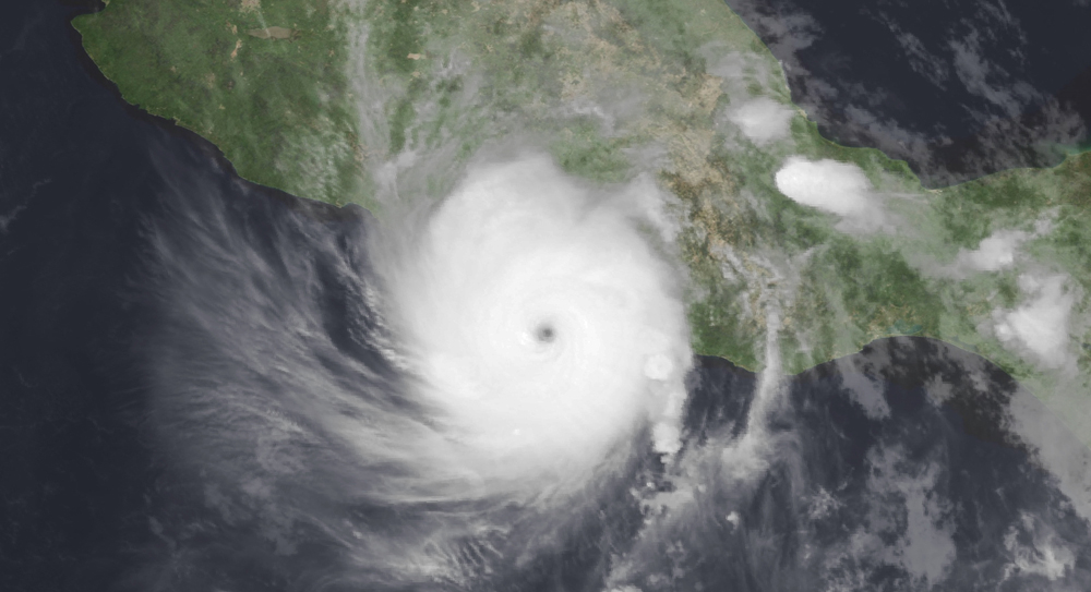
One of the modes discussed by Judt and his co-authors occurs when a hurricane intensifies symmetrically, fueled by favorable environmental conditions such as warm surface waters and low wind shear. This type of abrupt strengthening is associated with some of the most destructive storms in history, such as Hurricanes Andrew, Katrina, and Maria. Meteorologists were stunned this week when the winds of Hurricane Otis defied predictions and exploded by 110 miles per hour in just 24 hours, plowing into the west coast of Mexico at category 5 strength.
Judt and his co-authors also identified a second mode of rapid intensification that had previously been overlooked because it doesn’t lead to peak winds reaching such destructive levels. In the case of this mode, the strengthening can be linked to major bursts of thunderstorms far from the storm’s center. These bursts trigger a reconfiguration of the cyclone’s circulation, enabling it to intensify rapidly, reaching category 1 or 2 intensity within a matter of hours.
This second mode is more unexpected because it typically occurs in the face of unfavorable conditions, such as countervailing upper-level winds that shear the storm by blowing the top in a different direction than the bottom.
“Those storms are not as memorable and they’re not as significant,” Judt said. “But forecasters need to be aware that even a storm that’s strongly sheared and asymmetric can undergo a mode of rapid intensification.”