What we Talk About When We Talk About the Jet Stream and El Niño
Posted
Last Updated
By climate.gov.
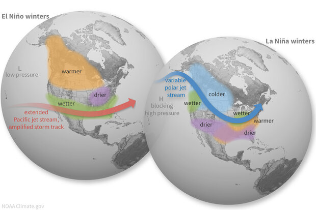
A robust El Niño is developing in the tropical Pacific, and we’re looking ahead to potential impacts on winter weather and climate. For specifics on this upcoming winter, you’ll have to wait for next month, when NOAA CPC will release their winter outlook. Today, I’m going for the big picture—how does the temperature of the surface of the tropical Pacific, thousands of miles away, change rain, snow, and temperature patterns over North America? The short answer: by shifting the location and strength of the jet stream.
Let’s back up a bit, though. Any time we talk about the jet stream, we first need to define what we’re talking about, before getting into changes in its behavior and how that leads to changes in weather and climate. And, before I get into the jet, one additional quick definition: weather vs. climate. Weather is the short-term conditions, lasting minutes to days, and highly variable. Climate is the average conditions over a longer period, such as a week, month, season, years, or longer. ENSO (El Niño/Southern Oscillation, the entire El Niño and La Niña system) is a seasonal climate pattern that lasts for several months in a row and affects winter climate—average rain/snow and temperature patterns over the course of the season—over North America and many other parts of the globe.
Jet engine
The jet stream, a fast, narrow current of air flowing from west to east high up in the atmosphere, is the mechanism connecting ENSO to North American winter climate patterns. Although the jet itself is high up and can reach speeds over 200 mph, the lower edges can extend all the way to the surface, at much lower speeds. There are lots of jets in the atmosphere, but on the ENSO Blog, we often talk about the Pacific subtropical jet stream, which owes its existence to tropical heating and the rotation of the Earth.
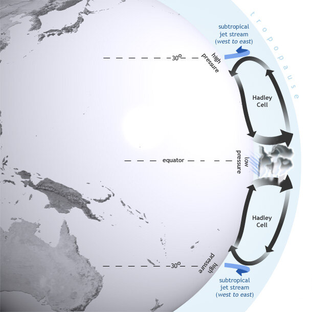
The sun heats the tropical land and oceans, causing lots of warm, moist air to rise. As that air gets high up in the atmosphere, it has to go somewhere, so it flows north and south. Eventually, it cools and sinks back to near the surface around 30 ° latitude in both hemispheres. From there, it flows back toward the equator. This loop is called the Hadley circulation.
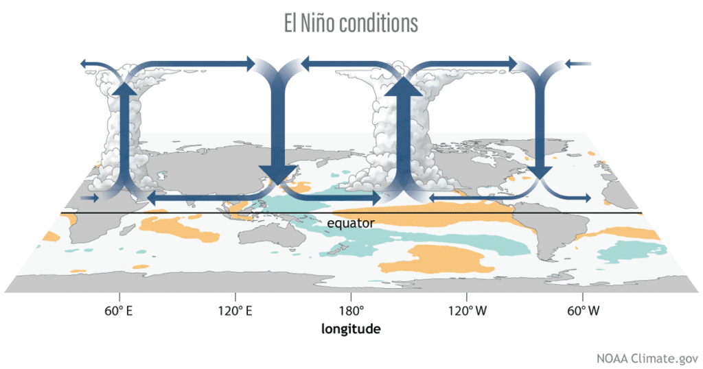
El Niño influences global atmospheric circulation by intensifying the Hadley circulation, in which heat is transferred from the Earth’s surface to the upper atmosphere through convection and latent heating. Map by NOAA Climate.gov.
The subtropical jet forms near the northern edge of the Hadley cell, high up in the atmosphere. Let’s just talk about the Northern Hemisphere for the moment, for simplicity. Because the Earth is rotating from west to east, the path of a moving air parcel bends to the right (this Coriolis force is also why hurricanes and other storms rotate counterclockwise in the Northern Hemisphere). Around 30° north and south of the equator, the Coriolis force is strong enough bend the air flow so it’s west-east. So, the air traveling northward in the Hadley cell gradually turns toward the east, speeding up as it goes. It speeds up for the same reason a spinning figure skater speeds up when they pull in their arms—the air is closer to the axis of rotation and must accelerate to maintain the same relative speed. Voila, the jet stream!
Of course, this is Earth, so nothing ends up being quite as simple as all that—the jet certainly never flows in a straight west-to-east line, and it is stronger and weaker in various areas—but that’s the big picture of why the subtropical jet stream exists. (See footnote.) The jet stream is a dividing line between cold northern air and warmer tropical air, and a track for storms. It also transports a lot of air around, so if the jet changes position, regions of higher and lower air pressure also shift. So, if you move the average position of the jet, you move what regions end up warmer or cooler than average, and where the rain and snow end up falling. El Niño and La Niña, through their impact on the jet stream, thus impact temperature and rain/snow patterns.
Jet set
All righty, so how does ENSO change the jet? First, imagine the atmosphere is a large pond. There’s a fountain in this pond that creates a pattern of ripples and currents in the pond. If you move the fountain, you’re going to change the pattern of ripples and currents. In the case of the atmosphere, that fountain is the very strong rising air and storminess that sits over the very warm waters of the far western Pacific.
Even though the sun heats the tropics evenly, the rotation of the Earth and the shape of the Pacific Ocean basin create this warm-west, cool-east pattern. This region of very strong rising air over the very warm water of the western Pacific results in a an amped-up north-south Hadley circulation.
El Niño’s warmer-than-average surface water in the central/eastern Pacific shifts the “fountain” to the east. La Niña enhances the warm-west, cool-east surface temperature pattern and further strengthens the rising air over far western Pacific—so the fountain is located in the same place, but is stronger.
Read More at climate.gov.


