Tropical Storm Erin Becomes First Atlantic Hurricane of 2025, Prompting Regional Port Closures
Posted
Last Updated
By UH Harbor.

Key Takeaways from Hurricane Erin Advisory 24 (August 17, 2025)
Immediate Threats (Today – Monday)
Heavy Rainfall and Flooding
- Continued heavy rainfall across Virgin Islands and Puerto Rico today
- Risk of flash flooding, urban flooding, landslides, and mudslides
- Rainfall amounts of 4-6+ inches expected in affected areas
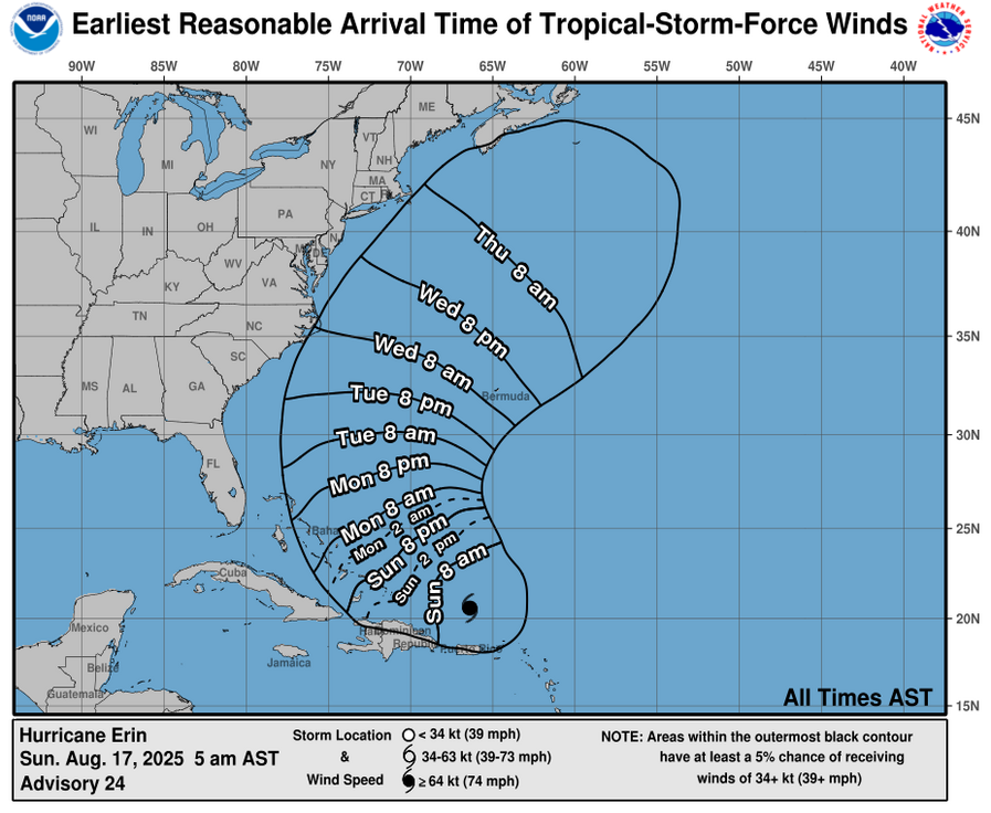
Tropical Storm Conditions
- Tropical storm conditions expected in Turks and Caicos Islands tonight and Monday
- Possible tropical storm conditions in Southeast Bahamas
- Tropical storm force wind gusts possible in Puerto Rico’s outer rainbands today
- Similar conditions expected in central Bahamas Monday-Tuesday
Extended Regional Impacts (Next Several Days)
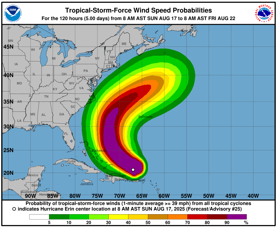
Life-Threatening Marine Conditions
- Dangerous surf and rip currents along beaches in the Bahamas
- Similar hazardous conditions expected along much of the U.S. East Coast
- Threats extend to Bermuda and Atlantic Canada over several days
Monitoring Areas
- North Carolina and Mid-Atlantic coasts should track Erin’s progress
- Bermuda faces potential risk of strong winds from outer rainbands mid-week
- Risk period extends through the middle part of the week
Storm Characteristics
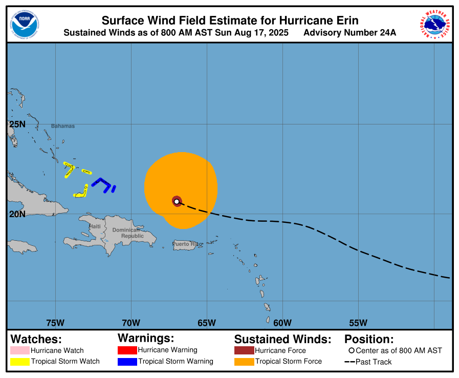
Current Status
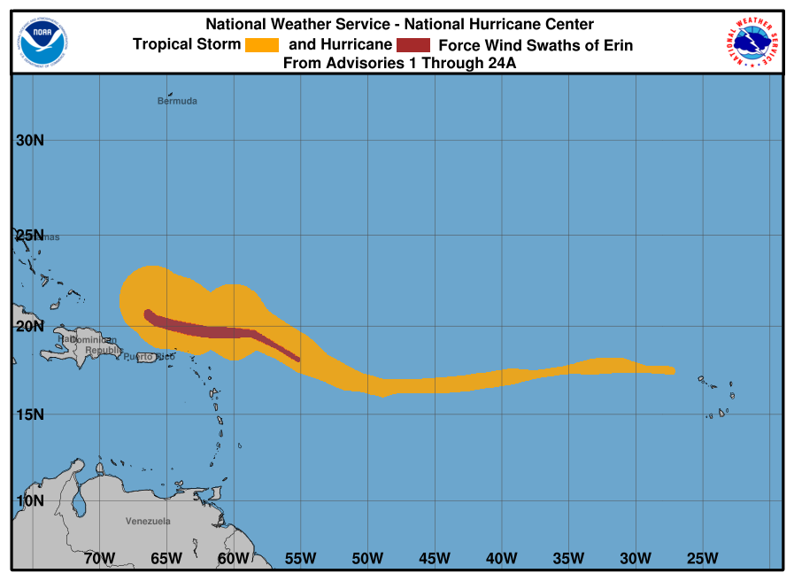
- Hurricane Erin maintains significant strength and organized structure
- Storm track shows northeastward movement away from Caribbean
- Rainfall forecast shows heaviest precipitation (6+ inches) concentrated in core area
Geographic Impact Zone
- Primary impacts focused on Caribbean islands and Bahamas
- Secondary effects (surf/rip currents) affecting much broader U.S. East Coast region
- Storm’s influence extends from Caribbean to Canadian Atlantic provinces
Major Maritime Disruptions
Tropical Storm Erin officially strengthened into Hurricane Erin on Friday, becoming the first hurricane of the 2025 Atlantic season. The storm’s upgrade comes earlier than the historical average first hurricane date of August 11, signaling an active season ahead for maritime operations.
Maritime Operations Impact
Hurricane Erin has disrupted Caribbean shipping and port activities. The U.S. Coast Guard closed six seaports in Puerto Rico and two in the U.S. Virgin Islands to all incoming vessels, except those with prior authorization. The storm’s track through busy Caribbean shipping lanes affects maritime traffic between the United States, Puerto Rico, and other Caribbean islands.
Storm Development and Response
Erin rapidly strengthened over exceptionally warm Atlantic waters and may reach major hurricane status. Federal agencies deployed over 200 personnel to Puerto Rico while officials prepared 367 emergency shelters. Bahamas authorities activated emergency protocols, emphasizing hurricane tracks’ unpredictable nature.
Forecast Implications
Current models show Erin taking a northeastward turn between the U.S. East Coast and Bermuda next week. While major U.S. ports should avoid direct impact, the storm will generate dangerous surf and rip currents along the Eastern Seaboard, with waves potentially reaching 15 feet along North Carolina’s coast. These conditions will affect recreational boating, fishing operations, and smaller commercial vessels.
Conclusion
Hurricane Erin’s early formation and rapid intensification serve as a clear warning for the 2025 Atlantic hurricane season. Maritime operators, port authorities, and coastal communities should use this storm as a reminder to review and strengthen their emergency preparedness protocols. With forecasters predicting an unusually active season ahead, the coordinated response to Erin demonstrates the critical importance of proactive planning in protecting both maritime infrastructure and the shipping industry that depends on it.


