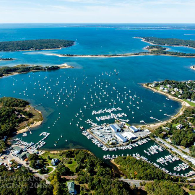
The buildings and wharf of the Woods Hole Oceanographic Institution are northwestward of the ferry pier. Northwestward of the Oceanographic Institution are the wharves of the Marine Biological Laboratory; the wharf, basin, and buildings of the National Marine Fisheries Service; the town pier; and several private buildings.
Depths at the principal piers vary from 11 to 30 feet. A breakwater extends about 90 yards southwestward from the south end of the National Marine Fisheries Service wharf. The front entrance range light is near the end of the breakwater. Foul ground extends about 50 yards northwestward of the outer end of the breakwater.
Eel Pond, an extension of Great Harbor to the northeastward, is a basin with depths of 10 to 20 feet. In 2001, the narrow entrance to the pond had a reported controlling depth of 6 feet. A highway bridge over the entrance channel has a 31-foot bascule span with a clearance of 5 feet. The piers of the Marine Biological Laboratory are along the southwest side of the pond. A boatyard in Eel Pond has water, some marine supplies, limited berths with electricity, and can do engine repairs. The harbormaster has an office in Falmouth.
Navigation:
Click the “Map View” button above to see a chart of this harbor.
Woods Hole is that water area lying between the southwest tip of Cape Cod and Uncatena and Nonamesset Island, the easternmost of the Elizabeth Islands, with Buzzards Bay on the northwest and Vineyard Sound on the southeast; it includes Great and Little Harbors in the eastern part, and Hadley Harbor in the western part. Woods Hole is also the approach to the town of Woods Hole on the northeastern shore of Great Harbor.
The most prominent landmark approaching Woods Hole is Nobska Point and light. A light marks the south end of Juniper Point, the finger of land separating Little and Great Harbors. Also prominent is the house high on Juniper Point, a standpipe 0.7 miles north-northwestward of Nobska Point, a water tower and stacks in the town, the dome of the Woods Hole Oceanographic Institution, and the buildings of the National Marine Fisheries Service and the Marine Biological Laboratory.
Woods Hole Passage, a dredged section through the northern part of Woods Hole, connects Vineyard Sound and Great Harbor with Buzzards Bay, and consists of The Strait and a spur channel known as the Branch at the western end of The Strait, and Broadway, the southerly entrance to The Strait from Vineyard Sound. A Federal project provides for channel depths of 13 feet.
The entrance to Great Harbor from Vineyard Sound, between Great Ledge and Nonamesset Shoal, has depths of over 20 feet. A 344° lighted entrance range leads into the harbor from Vineyard Sound to the wharves at Woods Hole in Great Harbor. A lighted bell buoy marks the entrance and lighted and unlighted buoys mark the channel. When entering on the range, mariners should guard against the current from Buzzards Bay, which has a tendency to set vessels eastward.
These channels are marked by buoys and lights, but extreme caution and slack water are required to safely navigate them with drafts greater than 8 feet. Mariners entering from Buzzards Bay should keep in mind that the buoys are colored and marked for passage from Vineyard Sound to Buzzards Bay.
Numerous ledges and shoals border the channel through Woods Hole. Great Ledge, an extensive rocky shoal awash at low water with a full northwest gale, lies between the entrances to Little and Great Harbors; it is marked by a buoy. Coffin Rock, eastward of Great Ledge and covered 5 feet, is marked by a lighted buoy 120 yards eastward of the rock. Nonamesset Shoal, covered 10 feet, extends about 0.2 mile eastward from Nonamesset Island, at the entrance to Great Harbor. Parker Flats extend as much as 200 yards off the eastern shore of Great Harbor northward of Juniper Point. Most of these dangers are marked by buoys.
Fringing the passage westward of Great Harbor are many other ledges and shoals. Red Ledge, grassy, and Grassy Island, with its surrounding ledge marked by a light, are on the western side of Great Harbor Channel. Middle Ledge, which uncovers 1 foot in places and is marked by buoys, is on the south side of The Strait. A ledge, awash at low water and marked by a light, is about 250 yards westward of Middle Ledge. Hadley Rock, covered 5 feet, is some 500 yards west-southwestward of the light west of Middle Ledge. A rocky shoal area extends more than 0.3 mile westward of Penzance Point, the southern extremity of Penzance, which is the curving peninsula sheltering the west and northwest sides of Great Harbor. Most of the dangers adjoining the passage channel are marked by navigational aids.


