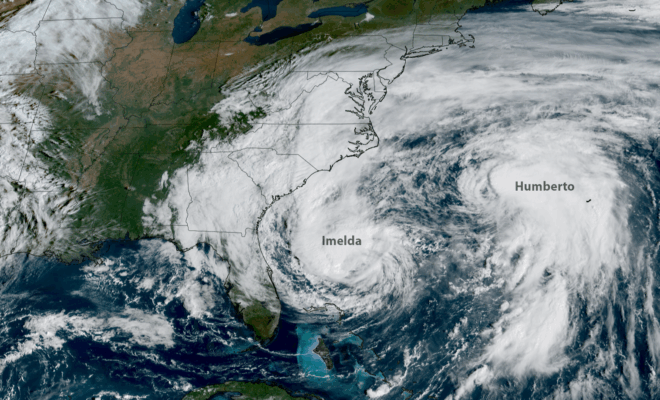
NOAA’s GOES-19 satellite captured images of hurricanes Imelda (left) and Humberto (right) churning off the U.S. East Coast on Sept. 30, 2025. (Image credit: NOAA Satellites)

2025 Atlantic Hurricane Season Marked by Striking Contrasts

11/30/2025 - By noaa.gov, noaa.gov. Seasonal activity fell within NOAA’s predicted ranges The 2025 Atlantic hurricane season, which officially ends on November 30, was notable for its striking contrast — wavering between periods of relative calm and bursts of intense activity, generating very powerful storms. Overall, the season fell within the predicted ranges… SEE MORE

Porites cf. lobata is a key reef-building coral that provides habitats for numerous species, including feather stars (comatulid crinoids) and fish. (Photo by Kharis Schrage, ©Woods Hole Oceanographic Institution)

Palau’s Rock Islands Harbor Heat-resistant Corals

11/15/2025 - By Woods Hole Oceanographic Institution, whoi.edu. Heat-Resistant Corals Discovered in Palau's Rock Islands As marine heatwaves increasingly threaten coral reefs worldwide, new research from Palau offers promising insights for harbor and coastal communities that depend on healthy reef ecosystems for shoreline protection, fisheries, and maritime navigation safety. The discovery of… SEE MORE
Image Credits: rawpixels.com.

Study Links More Frequent and Severe Heat Waves to Pollution from Major Fossil Fuel Producers

9/10/2025 - By Isabella O'Malley. Fifty-five heat waves over the past quarter-century would not have happened without human-caused climate change, according to a study published Wednesday. Planet-warming emissions from 180 major cement, oil and gas producers contributed significantly to all of the heat events considered in the study, which was published in the journal… SEE MORE
Image Credits: Getty Images.

Assessing the U.S. Temperature and Precipitation Analysis in July 2025

8/10/2025 - By ncei.noaa.gov. Record overnight warmth dominated the eastern U.S. in July and multiple regions across the country were impacted by flash flooding Key Point: Warm overnight minimum temperatures set July records, impacting more than 55 million people across the eastern states. In July, 1,434 flash flood warnings—the second-highest July total… SEE MORE
Image Credits: Pexels.

Mapping the Waters of Valdez, Alaska for Tsunami and Landslide Preparedness

7/31/2025 - By oceanservice.noaa.gov. A new partnership between NOAA and the City of Valdez, Alaska will help emergency managers prepare for future earthquakes, tsunamis, and underwater landslides. This partnership will support mapping 34 square nautical miles of the Port of Valdez — an important gateway to interior Alaska. A devastating earthquake in 1964 caused… SEE MORE
Image Credits: Animalia.

The Gentle Wisdom of Pacific Rockfish: A Story of Natural Adaptation

7/29/2025 - By US Harbors. Discovering how one of the ocean's most patient survivors navigates changing waters—and what it teaches West Coast anglers. Something beautiful is unfolding beneath Pacific waters. As ocean conditions gently shift and change, black rockfish have revealed a survival approach that speaks to nature's quiet wisdom: they're thoughtfully… SEE MORE
Image Credits: ncei.noaa.gov.

May Brought Storms and Heavy Rain from the South to the Northeast; Spring was the Second Warmest on Record

6/13/2025 - By ncei.noaa.gov. Key Points: Thirteen states experienced one of their five wettest Mays on record, while dry conditions persisted across much of the Northwest. Two significant severe weather outbreaks on May 15–16 and May 18–20 resulted in over 200 tornado reports, very large hail and damaging winds. Alaska had its… SEE MORE
Lane Simmons of the U.S. Geological Survey collects a water-quality sample at the Mississippi River at Baton Rouge, Louisiana (USGS 07374000). Credit: Scott Dennis, USGS.

NOAA Forecasts an Average Summer ‘Dead Zone’ in Gulf

6/11/2025 - By oceanservice.noaa.gov. Low-oxygen conditions expected to impact 5,574-square-mile area NOAA is forecasting this summer’s Gulf of America (formerly Gulf of Mexico) “dead zone” to be average-sized, covering approximately 5,574 square miles — an area roughly three times the size of Delaware. The dead zone, or hypoxic zone, is an area of… SEE MORE