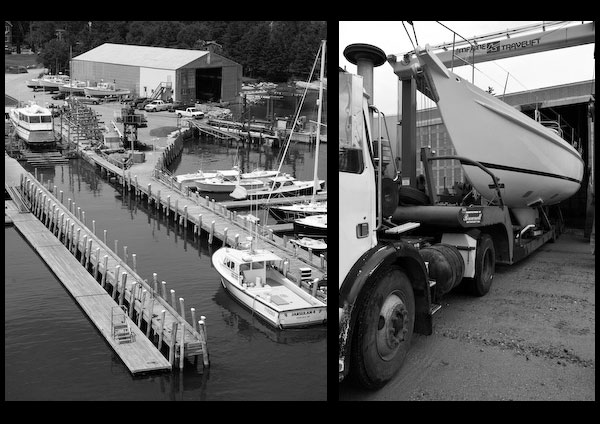
Most of the wharves along the Stonington waterfront are used by commercial vessels. The cannery wharf (44°09’15″N., 68°39’38″W.), on Staple Point, has reported depths of 7 feet along its easterly side. A ledge off the wharf has little water on it; a buoy marks the outer end. A lobster wharf, 200 yards west of the cannery wharf, has depths of 7 feet reported alongside. A private pier and float, about 50 yards northwest of the lobster wharf, is used by the Stonington-Isle au Haut mail and passenger ferry; depths of 5 feet are reported alongside. Two lobster wharves, about 250 and 500 yards eastward of the cannery wharf, have reported depths of 10 and 7 feet, respectively, alongside their float landings. There are also several fish wharves at the western end of the harbor, eastward of Green (Greens) Head.
Most of the facilities are along the main waterfront. Provisions and marine supplies can be obtained in town. The nearest vessel repair facility is on Moose Island, just westward of Stonington.
Berthage for transient craft is very limited at Stonington; most vessels anchor off the town or moor to mooring buoys off Staple Point. The town selectmen issue permits for mooring.
Stonington has banks, restaurants, markets, stores, hotels, and motels.
Allen Cove, just west of Stonington and east of Moose Island, is protected by a pier and breakwater built out from the southeast end of Moose Island. It is known locally as Yacht Basin. Sheds of a shipyard on the southeast end of Moose Island are prominent from westward. A causeway connects Moose Island with Deer Isle. Large lobster pounds occupy the northeast end of the cove and the areas on both sides of the causeway.
The shipyard builds vessels up to 80 feet long and has several marine railways that can handle vessels up to 250 tons or 125 feet long for general hull or engine repairs; electrical and electronic repairs can also be made. A 30-ton mobile hoist and open or covered dry storage are available. Gasoline, diesel fuel, electricity, water, ice, and marine supplies can be obtained at the yard’s service floats. The shipyard piers have depths of 10 feet reported alongside. Small craft anchor in the cove.
Navigation:
Click the “Map View” button above to see a chart of this harbor.
There are two well-marked channels into Deer Island Thorofare from the eastward. The northern channel passes east and south of the buoys marking the ledges off Green Ledge, 0.8 mile eastward of Stinson Neck, and enters the thorofare between Long Ledge, 0.5 mile south of Green Ledge, and Potato Ledge, which extends 0.6 mile northeastward from Shabby Island, 20 feet high and wooded. A daybeacon is on Long Ledge, and a bell buoy is south of the ledge. A buoy is north of Potato Ledge. The channel then leads westward, passing south of Lazygut Ledge, 0.6 mile west of Long Ledge, and entering the thorofare at Eastern Mark Island Ledge, 1.4 miles west of Potato Ledge. The channel then continues between Sheldrake Ledge and Haycock Rock, marked by a daybeacon, 0.6 mile southwest of Eastern Mark Island Ledge; between Haskell Ledge, 0.8 mile west of Haycock Rock, Bold Island Ledges, and several other dangers, most of which are buoyed. The northern channel then joins the southern channel in the thorofare west of Bold Island Ledges, 3.5 miles west-southwestward of Potato Ledge.
The southern entrance channel passes south of Whaleback Ledge, about 0.8 mile southward of Shabby Island, and runs nearly due west between Shingle Island, 1.1 miles southwest of Shabby Island, and Saddleback Island, 0.4 mile south of Shingle Island. The channel then swings northwestward and passes between Bold Island, 1.3 miles west of Shingle Island, and Bold Island Ledges. This channel is well marked by buoys to its junction with the other channels. Its eastern entrance is marked by a fairway bell buoy, about 700 yards east-northeastward of Saddleback Island.
Entering from the westward, the principal leading mark is near Deer Island Thorofare Light (44√Ç°08’04″N., 68√Ç°42’12″W.), 52 feet above the water, shown from a white square tower on the west side of Mark Island; a sound signal is at the light. Westward of the light care must be taken to avoid The Brown Cow, a ledge with a rock 3 feet high on it, 1.3 miles southwestward from the light, and West Mark Island Ledge, covered 4 feet, about 0.7 mile northwestward of the light; a buoy is south of the ledge. Passing north of the light and south of Western Deer Island Ledge, 5 feet high, and Bay Ledge, covered 11 feet, 0.4 mile north of Mark Island, there should be no difficulty in following the aids, which are colored and numbered for passage westward.


